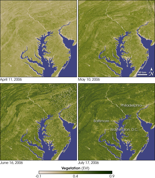
Spring green-up in the mid-Atlantic. NASA image created by Jesse Allen, using data obtained from the Goddard Land Processes data archives.
Thousands of webcams pointed at roads, airports, parks, and other outdoor environments could enable researchers to monitor climate change on a continental scale.
We know that climate change is shifting the timing of some plant phenology (flowering, budding, senescence) in some environments. Yet monitoring large scale changes is difficult—satellite images suffer from inaccuracies due to cloud cover, while on-the ground monitoring is accurate but expensive.
So researchers from UCLA tested a webcam approach, based on the notion that public cameras installed for other purposes are free online. They collected images twice a day from more than 1,100 georeferenced public webcams across North America from February 2008 to 2009. Their findings:
- Webcams are as good or better at detecting the spring green-up and the fall die-off than satellite-based data
- Webcams have fewer poor quality days, shorter continuous bad data days, and significantly lower errors of spring and fall estimates in various vegetation types
The data weren’t perfect. The researchers lacked control over where the cameras were looking and for how long. They provided hugely varying image resolution. Some cameras disappeared suddenly.
Yet overall the results were extremely useful for large scale monitoring. From the abstract:
“Additional advantages of a public camera-based monitoring system include frequent image capture (subdaily) and the potential to detect quantitative responses to environmental changes in organisms, species, and communities. Public cameras represent a relatively untapped and freely available resource for supporting large-scale ecological and environmental monitoring.”
The paper is in Global Change Biology. Thanks to Conservation Maven for the link.
